DIGITAL SOLUTIONS
IPI Utility Software
Overview
Overview
RST Instruments’ MEMS Digital In-Place Inclinometer (IPI) System is designed to reliably measure lateral movement in and around dams, embankments, landfills, landslides, piles, piers, retaining walls, and abutments, particularly when continuous remote monitoring is required. It provides an early warning for movement, essential for protecting life and equipment.
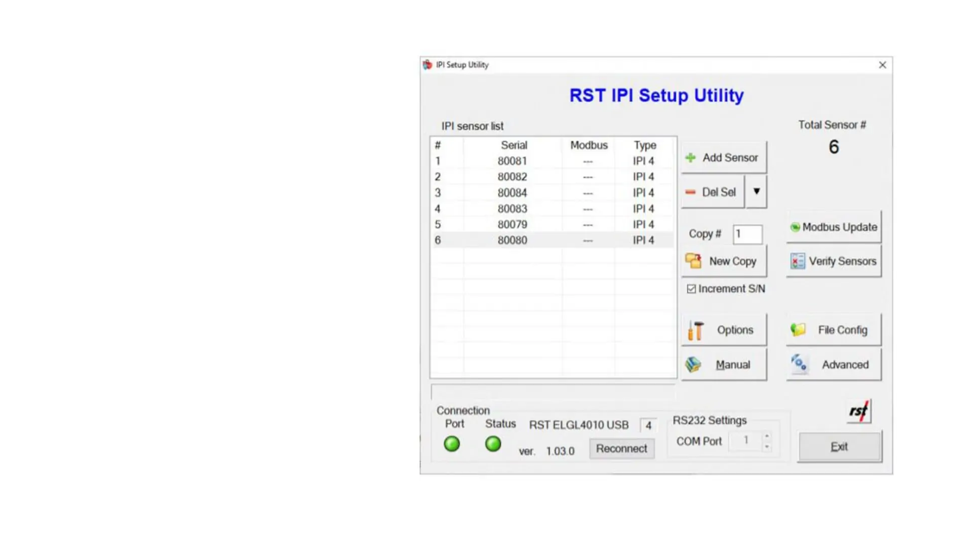
Each IPI sensor is identified by a factory-programmed unique serial number. When using the Modbus communication mode, each IPI sensor will be referenced by a unique Modbus address. Modbus addresses need to be programmed by the user each time a new IPI system is assembled and installed in the field, or when sensors are added to or replaced in an existing system.
The RST IPI Utility was created to facilitate programming the Modbus addresses in the field. It uses a familiar Microsoft Windows graphical interface. This manual outlines the procedure required to assign Modbus addresses to an IPI system.
The Modbus address is stored in the non-volatile memory of each IPI unit. As such, the procedures outlined in this manual will only need to be performed once per string, unless new units are added to a previously configured string.
It is important to note that the instructions included in this manual are specific for RST’s IPI27050 series IPIs with serial numbers greater than 80000. However, some earlier generations of RST’s IPIs may also be configured to use Modbus communication. Please contact RST for further information.
Visit the downloads section below to retrieve the software files. By downloading software from the RST Instruments website you agree to the terms of our license agreement. Please read it here before downloading.
Benefits
Benefits
Data insights
Ease of use
Improve safety
Features and benefits
Features and benefits
The IPI Utility Software is compatible with RST’s MEMS Digital In-Place Inclinometer. This software is used for IPI system setup and diagnostic.
Resources
Resources
Industries
Industries
Civil infrastructure
Energy
Surface metal
Underground mining
Related products

Digital Solutions
RSTAR Affinity Digital Suite

Digital Solutions
Inclinalysis Digital Inclinometer Software

Digital Solutions
Spiral File Format Converter

Digital Solutions
Digital Inclinometer App

Digital Solutions
DT Logger Host Software

Digital Solutions
RSTAR RTU Host Software

Digital Solutions
RST Readout Host Software

Digital Solutions
Portable Tilt Meter Host Software

Digital Solutions
Tilt Meter Host Software

Digital Solutions
VW Analog Interface Software
RST Instruments range

Digital Solutions
RSTAR Affinity

Digital Solutions
Data Loggers

Digital Solutions
Software

Digital Solutions
Piezometers

Digital Solutions
Inclinometers

Digital Solutions
Tiltmeters

Digital Solutions
Settlement Systems

Digital Solutions
Extensometers

Digital Solutions
Crack Meters

Digital Solutions
Strain Gauges and Strain Meters

Digital Solutions
Pressure Cells

Digital Solutions
Load Cells

Digital Solutions
Thermistors

Digital Solutions
Signal Cables

Digital Solutions
Readouts

Digital Solutions
Service and Partners
Explore more
We are a global leader in geotechnical, geospatial and structural monitoring. We deliver a complete portfolio, from sensors to services, for mining and civil infrastructure customers. Our expertise is grounded in Orica's innovation and technical excellence that span more than 150 years.

Contact an expert
Contact an expert