
Whitepaper
landslide-monitoring-in-brazil-and-the-uk
13 Feb 2025
This white paper summarises the original paper titled: Lesson Learned from Five Case Studies and Reveal Contributing Factors to Fatalities in Mining Industries Insights from Slope Stability Monitoring
AUTHORS
Winda Putri Anggraeni* Dwi Prio Utomo* Rahardian Dwitya* Rachmat Hamid Musa*
*GroundProbe Geotechnical Support Services, Balikpapan, Indonesia Contact: [email protected]
ABSTRACT
Slope failures pose significant risks in mining, potentially leading to catastrophic events that endanger both personnel and assets. Effective slope stability monitoring is critical for mitigating these risks. This study examines factors contributing to fatal slope failures through case studies from multiple mines across different regions. While advanced monitoring systems identified unstable areas, incidents still occurred due to vulnerabilities such as improper implementation of Trigger Action Response Plans (TARP), unqualified personnel analysing data, insufficient monitoring coverage, inadequate system knowledge, and failure to detect warning signs. These findings highlight the need for improvements in slope monitoring practices. The research provides insights and corrective actions to enhance monitoring effectiveness and strengthen mining safety.INTRODUCTION
Slope stability in open-pit mining is essential for both economic and safety reasons, requiring well-designed, cost-effective excavated slopes to maintain stability. Over the past few decades, extensive research has advanced the understanding of slope failures, categorising contributing factors into internal and external influences. Internal factors include rock composition, geotechnical properties, and environmental conditions such as rainfall and weathering, while external factors are primarily related to human activity (Sha, 2016). Despite significant advancements in monitoring technology, fatal slope failures continue to occur, exposing gaps in existing systems and protocols. While monitoring systems provide critical data, effective slope stability management also requires skilled human intervention. The combination of advanced technology and well-trained personnel is essential for improving risk mitigation strategies and ensuring safer mining operations. Addressing both technological and organisational challenges is crucial to enhancing overall mine safety and reducing the likelihood of future slope failures.1.1. Risk of Slope Failure
Managing slope stability is critical in mining, as slope failures pose severe risks to both safety and productivity, leading to injuries, equipment damage, and operational disruptions. Numerous case studies and statistical analyses highlight the significant impact of slope failures on mining safety. A study found that over a ten-year period, slope failures accounted for approximately 30% of all mining-related fatalities (International Council on Mining and Metals [ICMM], 2016).
A major slope failure at the Grasberg Mine in Indonesia forced operations to halt (Down to Earth [DTE], 2021). In October 2003, a catastrophic failure on the southern wall killed eight people and injured five, displacing 2.3 million tons of rock and mud. A similar incident in 2000, triggered by heavy rainfall, caused a rock mass to slip into Lake Wanagon, West Papua (Graham, 2003).
In India, surface mine slope failures have led to substantial losses of life and property, with 23 catastrophic failures between 1901 and 2016 resulting in 143 fatalities. The Rajmahal disaster, a more recent event, tragically claimed 23 lives (Dash, 2019). These incidents underscore the significant and ongoing risks associated with slope instability in mining operations.
1.2 Importance of Slope Monitoring
Slope monitoring is crucial for risk management in mining and civil engineering projects. It plays a key role in identifying and mitigating potential instability that can lead to slope failures, rockfalls, or collapses, endangering lives and causing economic losses. The primary goal is to detect early signs of instability, enabling timely actions like evacuation, reinforcement, or redesign to prevent catastrophic events. Slope failures have historically led to fatalities and significant financial losses, especially in mining, where workers are often near unstable slopes. Slope monitoring allows engineers to track slope deformation and movement, providing data that can predict potential failures. This is vital as slope failures can occur without visible signs (Turner & Schuster, 1996). Monitoring systems, including radar-based, optical, and sensor-driven technologies, provide critical data to assess changes in slope behaviour and ground conditions, helping to identify instability patterns. Methods used in slope monitoring range from visual inspections to advanced techniques like LiDAR, GPS, Slope Stability Radar (SSR), and fibre optic sensing, offering high-precision, real-time data.1.3 Slope Movement Behaviour
Understanding typical deformation patterns is crucial when monitoring rock mass or construction deformation. These patterns help in early warning analysis, enabling the anticipation of potential failures. Depending on geological conditions, stress levels, and external factors, structures often show signs of movement before failure. A common pattern in rock mass behaviour includes stable, regressive, linear, and progressive movements, which may ultimately lead to failure (Dwitya et al, 2024). Failure occurs when the resisting force becomes smaller than the driving force. |
1.4 Massive Slope Failures in the Mining Industry
Slope failures are a common challenge in mining, with even minor incidents leading to significant losses. One of the most notable failures in history occurred at the Bingham Canyon Mine on April 10, 2013, near Salt Lake City, Utah. This event involved the movement of approximately 66.2 million cubic yards (144.4 million tons) of material, which slid more than 2,000 feet and travelled over 1.5 miles. The failure occurred in two phases, roughly 90 minutes apart, with each lasting about 90 seconds (Ross, 2017). Remarkably, no injuries or fatalities were reported. Proactive measures taken by mine personnel—including continuous monitoring, the relocation of buildings and equipment, and the construction of a backup road—helped mitigate the impact. The company’s swift response and well-executed safety protocols allowed the event to be managed as a crisis rather than a disaster, ensuring a smooth return to operations. This incident highlights the critical role of leadership, strategic planning, and teamwork in effectively managing geotechnical hazards in mining.MATERIALS AND METHOD
Geotechnical slope monitoring is essential in the mining industry, with each site employing its own instruments and strategies. Geotechnical engineers increasingly use advanced technologies to detect slope instability early in open-pit mines, managing risks more effectively. Despite identifying geotechnical risks, the possibility of multiple fatalities due to slope failures remains high. This study examines lessons learned from five case studies across Asia, Africa, and North America (2016-2024), where slope failures were identified early but still resulted in fatalities. Data was gathered from incident reports, news, discussions with on-site engineers, monitoring data, geotechnical articles, and other sources. By analysing these events, the study aims to prevent recurrence and enhance mining safety.Case Study 1: A coal mine in Asia, 2022
In 2022, a slope failure at a coal mine in Asia resulted in two fatalities and injuries to two others. The collapse also caused significant equipment losses, including one drilling unit and two excavators. The failure occurred within a high-risk fault zone previously identified by the on-site geotechnical team. Continuous monitoring with an SSR system detected slope movement in the area. Engineers observed a long-term linear deformation trend, indicating constant slope movement. Heavy rainfall the day before the failure further exacerbated the instability. Radar data showed progressive deformation five hours before the incident. At 4:00 a.m., the night shift engineer reported these findings via a mobile app. Although no operations were underway due to rain, a drilling machine remained parked nearby. The day shift engineer relayed the warning during the morning toolbox meeting. However, four heavy equipment operators missed the meeting and were unaware of the potential risks. Lacking critical information about the hazard, these operators were in the danger zone when the slope failed. No barricades had been installed to restrict access to the unstable area. At approximately 6:00 a.m., as the operators arrived on-site, the slope collapsed, sweeping away two operators and a drilling machine. Nearby excavators were also impacted, though their operators managed to escape with serious injuries. |
 |
Case Study 2: A coal mine in Asia, 2020
In 2020, a slope failure at a coal mine in Asia resulted in one fatality and three injuries. The victim was buried beneath mud embankment material and heavy equipment. The embankment had been designed to prevent mud from reaching the coal loading area. SSR monitoring detected slope movements on the low wall side, prompting engineers to track the data continuously for early warnings. Two days before the failure, progressive movement was identified in the embankment, but it was not flagged as high risk, as it did not meet the 10-pixel threshold for action. However, the monitoring team reported the findings to the on-site engineers. The following day, the movement became linear before transitioning to regressive. On the day of the failure, progressive movement was detected again an hour before the incident. Per Trigger Action Response Plan (TARP) procedures, the night shift monitoring engineer alerted the site team via phone calls, app groups, and emails. Despite the warnings, no evacuation was carried out, and operations continued. At 4:21 a.m., the slope collapsed, burying the operator inside a PC 400 cabin. Three other operators were away from the site at the time. A two-month search and recovery effort, led by the Emergency Rescue Team (ERT) and supported by advanced technologies such as Ground Penetrating Radar (GPR) and metal detectors, ultimately confirmed the tragic loss of the operator. |
Figure 4. Illustration of the failure of the slope embankment caused mud flooding in the work area, burying the operator and the excavators. A coal mine in Asia, 2020.
 |
Figure 5. Graph of the slope behaviour of the embankment. A coal mine in Asia, 2020.
Case Study 3: A cobalt and copper mine in Africa, 2016
In 2016, a geotechnical failure at a cobalt and copper mine in Africa resulted in seven fatalities. Three bodies were recovered two days later, while the remaining four workers were presumed dead. The incident also caused significant infrastructure damage within the pit. The slope failure affected approximately 20 benches, with a total height of around 200 metres. The mine was equipped with multiple ground-based radars monitoring the pit, and radar data indicated a gradual deformation sequence in the three weeks leading up to the failure. A linear deformation trend was observed, with a steady average velocity of approximately 7 mm/day, which escalated to 400 mm/day in the three days preceding the collapse. Despite this, the monitoring team’s report failed to highlight the significant and progressive deformation trend in the failure zone. Although notable movement was detected, no early warning was issued. The geotechnical team identified an increasing velocity of slope movement the day before the failure; however, the operations team did not evacuate all workers in time. At approximately 6:00 a.m., a massive failure occurred, claiming the lives of seven workers. Despite the presence of advanced monitoring technology and geotechnical oversight, the lack of timely intervention led to a tragic outcome. |
 |
Case Study 4: A copper mine in Asia, 2020
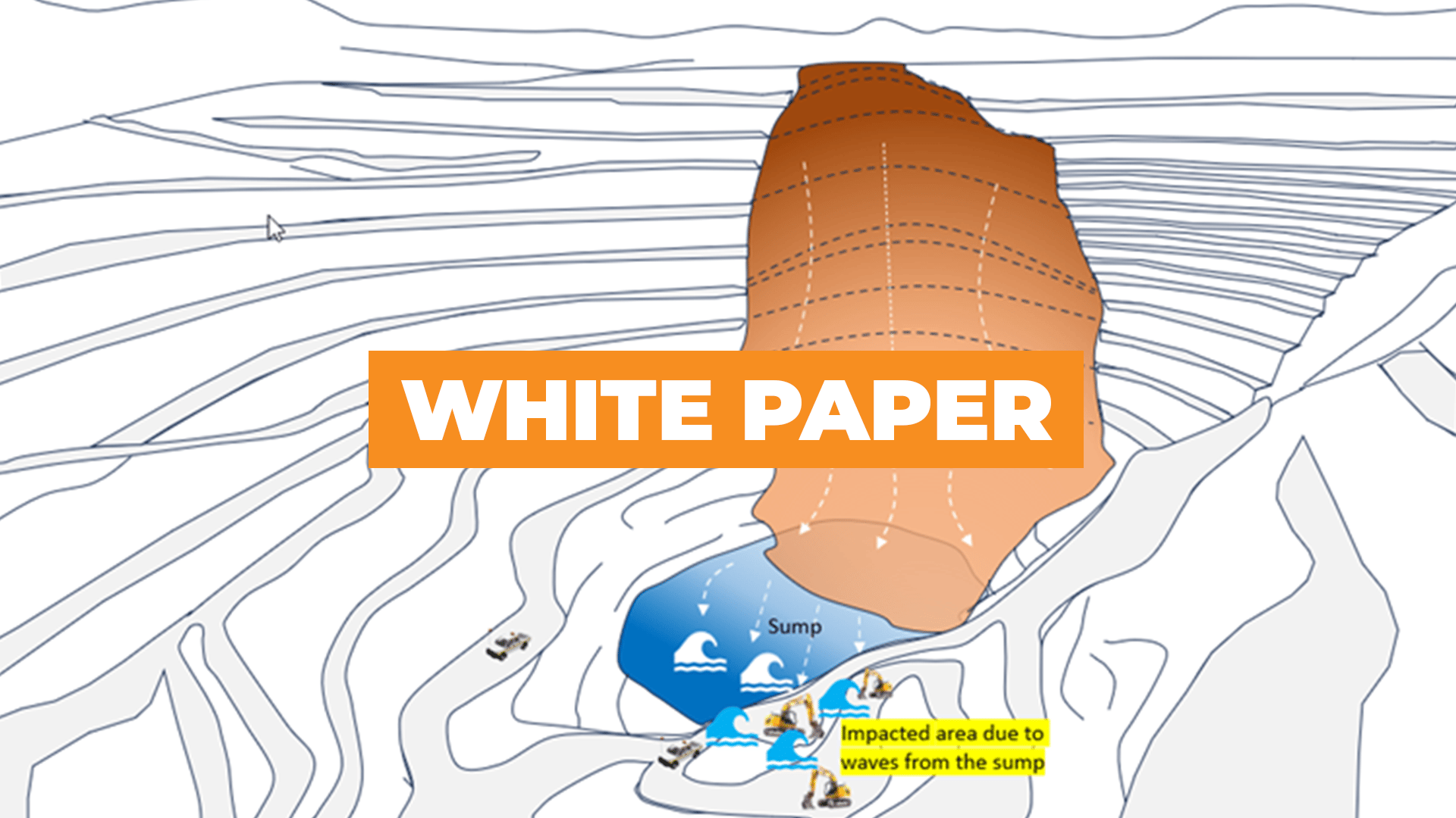
In 2020, a catastrophic slope failure struck a copper mine in Asia following a tropical storm. The incident resulted in four confirmed fatalities, while six workers remained missing, as reported during a meeting between the mining company and government officials the following day. Initial investigations revealed that no mining activity was taking place in the affected area at the time. The failure occurred at approximately 4:15 p.m. when debris from the slope collapsed into the pit, located at 41 metres above sea level. The displaced material generated a powerful wave, resembling a tsunami, which surged to an elevation of 105 metres, reaching the southern section of the pit where workers were present. Remarkable video footage captured the event, showing the slope slowly creeping downward for approximately two minutes before the wave reached the workers' location 50 seconds later. Several workers were seen desperately running to escape. The wave was triggered by the collapsing material pushing water at the pit bottom, which then surged toward the work area. Discussions with the engineering team later revealed that the potential for such a large-scale failure had been identified prior to the incident. |
Case Study 5: A gold mine in North America, 2024
In 2024, a slope failure at a gold mine in North America injured mining personnel and significantly damaged heavy equipment. The mine had been using an SSR system to monitor slope movements in areas with high operational activity, and the SSR was strategically positioned to monitor the failure area effectively. Radar data analysis required a connection between the radar and the geotechnical team's computer, which was set up via a Wi-Fi network extending from the pit to the geotechnical office through a repeater. However, approximately 14 days before the failure, the geotechnical team relocated the repeater to the pit area, and a request was made to reinstall the repeater for continuous data transmission. Due to a communication failure, the repeater was not reinstalled, which left the radar data disconnected from the geotechnical team’s computer. During the 14-day period without data transmission, the geotechnical team did not regularly check data availability, leading to the radar data being unreceived at the geotechnical office. In the critical zone under surveillance, an excavator was working alongside a dump truck. A slope failure on a 15-meter-high slope to the left of the truck resulted in debris hitting the operator’s cabin. Despite the radar’s data being available on the radar itself, it had not been transmitted to the geotechnical team’s computer. After the failure, technicians repaired the communication network, restoring the data flow. Post-incident analysis revealed a clear sequence of movements detected by the SSR: a linear movement starting two days before the failure, followed by progressive movement for six hours prior to the slope failure at 6 a.m. on May 6, 2024. The radar data provided a distinct record of the slope’s behaviour leading up to the event. |
 |
RESULTS AND DISCUSSION
3.1 Improper and Unimplemented TARP
The implementation of an effective Trigger Action and Response Plan (TARP) is essential for the safety of workers in the event of slope instability or failure. However, the success of a TARP is dependent on clear communication, a shared understanding of the risks, and the roles and responsibilities of personnel. When an alarm is triggered or movement is detected, the response should be swift and well-defined. Without input from the responsible persons and proper assignment of roles, TARPs risk being ineffective. Clear and straightforward communication is vital, and monitoring systems should be integrated with the TARP to provide real-time alerts. In the 2020 slope failure incident at a coal mine in Asia, the failure to properly implement TARP resulted in fatalities as the responsible person failed to inform workers of the hazard and ensure the exclusion area was clear. The lack of communication left the fleet and operators at risk, leading to tragic consequences. |