Blog
Choosing the right ground movement monitoring solution: Inclinometers and ShapeArray™ explained
25 Aug 2026
Monitoring ground movement is a critical part of geotechnical risk management, helping engineers understand how soil, rock and structures respond to changing conditions over time. Whether assessing the stability of a mine slope, dam, embankment, retaining wall or other critical infrastructure, reliable deformation monitoring data provides the insights needed to support safety, performance and informed decision-making.
A range of monitoring technologies are available to measure ground movement, each suited to different applications, levels of risk and monitoring objectives. Traditional manual digital inclinometer systems remain widely used for measuring subsurface displacement, while automated solutions such as MEMS Digital In-Place Inclinometer (IPI) Systems and ShapeArray™ provide continuous monitoring and real-time visibility into changing ground conditions.
RST Instruments and Measurand, part of Orica Digital Solutions, offer a comprehensive portfolio of ground movement monitoring solutions, ranging from manual digital inclinometer systems to advanced automated deformation monitoring technologies. Understanding the differences between these solutions can help engineers select the most appropriate approach for their project requirements.
Why monitor ground movement?
Ground movement monitoring provides valuable insights into how soil, rock and structures respond to changing environmental and operational conditions. The data can be used to:
- Assess slope stability
- Monitor ground creep and shear zones
- Verify the performance of ground support systems
- Detect early signs of instability
- Support safe construction and long-term asset management
Depending on project requirements, monitoring may be carried out through periodic surveys using manual digital inclinometer systems or continuous automated monitoring technologies such as In-Place Inclinometers (IPIs) and ShapeArray™.
Manual digital inclinometer systems
What they do
Manual digital inclinometer systems measure and assess subsurface ground and structural movement through periodic surveys. Depending on the application, these systems can measure lateral displacement, settlement and heave, or identify casing twist that may affect measurement accuracy.
Manual digital inclinometer systems are available in three primary configurations:
Manual digital vertical inclinometer systems
Used to measure lateral ground movement through inclinometer casing installed vertically in boreholes, embankments, piles or structures. The probe is lowered through the casing, and inclination measurements are collected at regular intervals to determine changes in ground displacement over time.
Typical applications
- Open pit mines
- Underground mines
- Dams
- Reservoirs
- Embankments
- Retaining structures
- Geotechnical investigations
Manual digital horizontal manual inclinometer systems
Used to measure settlement and heave beneath structures and earthworks. The inclinometer casing is installed horizontally, allowing engineers to assess subsurface vertical deformation and foundation performance.
Typical applications
- Embankments
- Dams
- Roadways
- Storage tanks
- Landfills
Manual digital spiral inclinometer system
Used to identify helical deformation or casing twist within inclinometer installations. Spiral measurements help verify casing orientation and improve confidence in inclinometer survey results, particularly in deep installations.
Typical applications
- Deep inclinometer installations
- Projects where casing twist is suspected
- Data validation and quality assurance programs
Key benefits of manual digital inclinometer systems
- Proven and widely accepted monitoring technology
- High-precision displacement measurements
- Flexible deployment across a wide range of geotechnical applications
- Cost-effective for projects requiring periodic monitoring
- Supports long-term performance assessment and stability evaluation
MEMS digital in-place inclinometer (IPI) system
What it does
Unlike manual digital inclinometer surveys, the In-Place Inclinometer (IPI) System remains permanently installed within the inclinometer casing and continuously monitors lateral ground movement. The system automatically collects data and can integrate with remote monitoring infrastructure, making it suitable for projects that require continuous monitoring and early-warning capabilities.
Best use cases
- Suitable where lower spatial resolution is acceptable and measurement points can be spaced at intervals along the borehole.
- Flexible configuration allows sensor spacing and installation lengths to be adapted to project requirements.
- On-site installation allows for length to be customized for each borehole on-site.
- Well suited to installations where borehole space is restricted or access conditions make deployment of larger monitoring systems challenging.
Key features
- MEMS-based sensor technology
- Continuous automated monitoring
- Remote data collection capabilities
- Compatibility with RSTAR Affinity and RST data loggers
- Configurable system architecture to suit project requirements
Key benefits
- Real-time movement detection
- Reduced requirement for site visits
- Early warning of developing instability
- Improved safety for personnel and infrastructure
- Continuous data streams to support informed decision-making
Typical applications
- Dams
- Embankments
- Landfills
- Landslides
- Piles
- Piers
- Retaining walls
- Bridge abutments
ShapeArray™
What it does
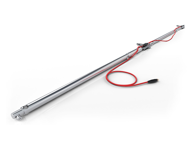
ShapeArray™ is an automated inclinometer-style instrument that continuously measures deformation along its entire length using integrated MEMS sensors. Unlike IPI’s, ShapeArray™ arrives on site assembled and ready to install with our simple cyclical installation, also provides high-resolution deformation profiles in near real time without requiring routine field surveys.
ShapeArray™ can be installed in boreholes, trenches, on surfaces or within structures to monitor deformation in soil, rock and infrastructure.
Best use cases
- Recommended for most continuous deformation monitoring applications
- Recommended where high-resolution deformation data is required.
Key features
- Automated continuous deformation monitoring
- High-resolution 3D deformation measurements
- Flexible design that simplifies installation
- Integrated MEMS sensor technology throughout the array
- Compatible with remote monitoring systems and software platforms
- Near real-time data collection and visualisation
Key benefits
- Continuous monitoring without routine field surveys
- Rapid installation compared with conventional inclinometer systems
- High-resolution deformation profiles along the entire monitored length
- Early identification of changing ground conditions
- Supports remote monitoring and risk management programs
- Improves decision-making through continuous data availability
Typical applications
- Open pit mines
- Tailings storage facilities
- Landslides
- Embankments
- Dams
- Tunnels
- Transportation infrastructure
- Structural deformation monitoring
Selecting the right ground movement monitoring solution
| Systems | What it measures | Monitoring method | Installation | Best for | Key benefit |
| Manual digital Inclinometer Systems (Vertical, Horizontal, & Spiral) | Lateral ground movement, settlement, heaves and casing twist | Periodic manual surveys | Inclinometer casing installed vertically or horizontally, with spiral surveys conducted within casing | Projects requiring accurate periodic displacement monitoring and assessment | Provides reliable, high-precision measurements while allowing engineers to evaluate a range of displacement and deformation conditions through scheduled surveys |
| In-Place Inclinometer System | Lateral ground movement | Continuous automated monitoring | Permanently installed in inclinometer casing | Real-time monitoring and early warning applications | Provides ongoing movement data and automated alerts, reducing site visits and improving risk management |
| ShapeArray™ | Continuous deformation and displacement monitoring | Continuous automated monitoring | Installed in boreholes, trenches, structures or on surfaces | Projects requiring high-resolution, real-time deformation monitoring | Provides continuous deformation measurements along the full length of the instrument, enabling rapid detection of changing ground conditions |
Quick selection guide
| If you need to ... | Recommended solution |
| Measure lateral movement in soil or rock through periodic surveys | Manual Digital Vertical Inclinometer System |
| Measure settlement or heave beneath structures | Manual Digital Horizontal Inclinometer System |
| Verify casing alignment or detect casing twist | Manual Digital Spiral Inclinometer System |
| Monitor lateral ground movement continuously using installed inclinometer casing | MEMS Digital In-Place Inclinometer (IPI) System |
| Access automated monitoring data and early warning alerts | MEMS Digital In-Place Inclinometer (IPI) System |
| Monitor deformation continuously along the entire length of a borehole or structure | ShapeArray™ |
| Obtain near real-time movement data and reduce field survey requirements | ShapeArray™ |
| Implement automated monitoring for higher-risk environments | ShapeArray™ |
Conclusion
Both Manual Digital Inclinometer Systems, MEMS Digital In-Place Inclinometer (IPI) Systems and ShapeArray™ play important roles in ground movement monitoring programs, with the most suitable solution depending on project objectives, monitoring frequency requirements and risk profile.
Manual Digital Inclinometer Systems provide a proven and reliable approach for measuring lateral displacement, settlement, heave and casing twist through periodic surveys. For applications that require continuous measurement of lateral ground movement, the MEMS Digital In-Place Inclinometer (IPI) System provides automated monitoring and remote data collection while utilising traditional inclinometer casing installations.
For projects requiring continuous monitoring, high-resolution deformation profiles and near-real-time visibility of changing ground conditions, ShapeArray™ offers an automated alternative that eliminates routine manual surveys while providing comprehensive deformation measurements along the entire monitored length.
Whether supporting mining, civil infrastructure, or construction projects, Orica Digital Solutions provides a comprehensive portfolio of ground movement monitoring technologies that help improve visibility, strengthen risk management, and support informed decision-making.
Learn more about Orica Digital Solutions' ground movement monitoring solutions:
▶️ RST Instruments Inclinometers:
▶️ Measurand ShapeArray™: