

Blog
Unlocking operational insights for subsurface injection and production with InSAR data webinar
19 Aug 2026
Your questions answered
Orica Digital Solutions' Reza Keshavarzi and Luke Muller from 3vGeomatics recently presented a webinar, Unlocking operational insights for subsurface injection and production with InSAR data. The duo took an in-depth look at how InSAR can support subsurface operations across energy and storage sectors. InSAR data can turn surface movement into continuous, full-field subsurface insight—so you can detect risk earlier, act faster, and make confident decisions.
 |
This webinar covered:
- A detailed overview of InSAR solutions for subsurface injection and production operations
- An in-depth look at applications of InSAR across multiple sectors, including oil and gas (both conventional and unconventional resources), saltwater disposal (SWD), carbon capture, utilization and storage (CCS/CCUS), geothermal energy, and natural gas storage.
- An understanding of how InSAR can strengthen regulatory and measurement, verification, and improve operational efficiency and decision-making
We received several questions during the webinar that we’ve answered below.
Question: What level of accuracy can InSAR achieve in tropical environments with dense vegetation cover, such as the Amazon region?
Answer: In heavily vegetated areas, shorter-wavelength sensors such as X-band and C-band experience significant signal decorrelation, which prevents InSAR measurements. As a result, L-band InSAR is the only option to monitor these areas because its longer wavelength can penetrate vegetation and maintain coherence. While it cannot achieve the millimeter-level precision commonly attainable in non-vegetated or sparsely vegetated environments, L-band InSAR can detect and monitor ground deformation at the centimeter scale, providing valuable insights into surface movement and underlying subsurface processes across large, remote vegetated regions. Where millimeter-scale precision in vegetated areas is required, strategically installed corner reflectors can provide stable measurement targets, enabling accurate deformation monitoring in vegetated environments.
Question: Can you detect north/south motion? Do you require full 3D to do so?
Answer: Yes. With 3vG's True 3D InSAR capability, north-south motion can now be measured directly from satellite observations.
Traditionally, satellite-based InSAR has provided line-of-sight (LOS) measurements, with vertical and east-west displacement components derived by combining observations from multiple viewing geometries.However, the north-south component has historically been difficult to resolve accurately using satellite observations alone. As a result, estimating full 3D ground motion typically required integrating InSAR with sparse ground-based measurements such as GPS/GNSS.
Through our partnership with Capella Space and its mid-inclination satellite constellation, combined with 3vG's proprietary 3D InSAR processing chain, we now offer True 3D InSAR, enabling direct measurement of ground displacement in all three dimensions: vertical, east-west, and north-south. This provides a more complete and accurate understanding of ground deformation without relying solely on ground-based instrumentation to resolve the north-south component.
Question: What is the minimum detectable movement and the highest resolution that InSAR can get?
Answer: InSAR can detect extremely small ground movements, typically on the order of a few millimeters and under ideal conditions. Spatial resolution depends on the satellite sensor used, while measurement precision is influenced by factors such as wavelength, acquisition geometry, coherence, and processing methodology. In general, shorter wavelengths can provide higher measurement sensitivity under suitable conditions, while longer wavelengths are better suited to maintaining coherence in vegetated environments.
Question: How far back can historical InSAR data go?
Answer: The availability of historical InSAR data depends on the location and the satellite archives covering that area, most likely back to 2014. We have access to extensive archives from multiple satellite missions and, in some regions, such as the Permian Basin, historical data can extend back more than a decade. The exact data availability varies by location, so we evaluate each area on a case-by-case basis. If you have a specific area of interest, we can review the available satellite archives and confirm the historical coverage.
Question: How can surface deformation measurements be used to assess reservoir depletion and pressure changes over time?
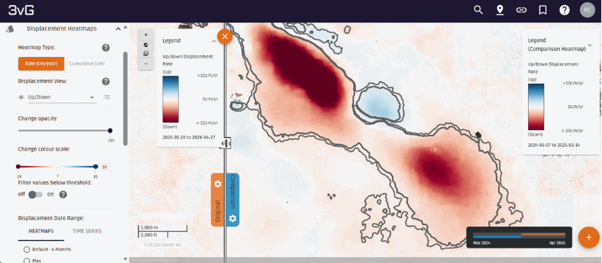
Answer: Surface deformation measurements provide a direct indication of how subsurface reservoirs respond to injection and production activities. Changes in reservoir pressure alter the stress state of the surrounding rock, often resulting in measurable uplift or subsidence at the surface. By monitoring these deformation patterns with InSAR, operators can identify areas experiencing the highest reservoir depletion or pressure change.
Time-series analysis of surface deformation can also provide insights into pressure communication and pressure propagation within the reservoir. By tracking how deformation evolves and spreads over time, it is possible to infer the direction and extent of pressure changes across the field. For example, if deformation progressively extends toward a particular area, it may indicate that pressure change is occurring in that direction.
While InSAR measures surface movement rather than reservoir pressure directly, surface deformation helps operators better understand reservoir depletion, pressure distribution, and reservoir connectivity over time.
 |
Question: How frequently can InSAR-derived deformation measurements be updated?
Answer: Update frequency depends on the satellite's revisit schedule. For free data sources such as Sentinel-1 and NISAR, updates are typically available every 6 to 12 days. Sentinel-1 revisit rates vary by location, while NISAR operates on a 12-day repeat cycle and provides an average revisit time of about 6 days when ascending and descending acquisitions are considered together.
For high-resolution commercial data such as TerraSAR-X (TSX), updates are typically available every 4 to 7 days.
COSMO-SkyMed (CSK) can provide revisit intervals as short as 1 to 4 days, which can be useful for monitoring faster-moving deformation and rapid events such as earthquakes or failures.
Question: How can InSAR support produced-water disposal and wastewater injection monitoring programs?
Answer: InSAR can support produced-water disposal and wastewater injection monitoring by detecting and tracking surface deformation associated with subsurface pressure changes. As injection activities increase pore pressure in the subsurface, the resulting geomechanical response can produce measurable surface displacement, providing valuable insights into the extent and evolution of injection-related impacts.
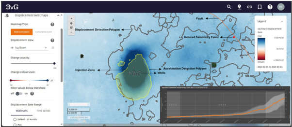
Through 3vG's Motionary® platform, deformation data can be analyzed alongside other critical datasets, including well locations, fault networks, induced seismicity events, SRV maps, infrastructure, and other geospatial information. This integrated view helps operators correlate observed surface deformation with subsurface activities, better understand the factors driving ground movement, and support risk assessment and operational decision-making.
3vG's displacement detection polygons can be of help to identify areas affected by injection-related pressure changes. In addition, 3vG's acceleration detection polygons highlight locations where deformation is getting accelerated. These accelerating movements can serve as an early indicator of elevated risk or changing subsurface conditions, such as pressure buildup, pressure migration, or other geomechanical responses that may warrant further investigation.
Together, 3vG's Displacement DataStream and Motionary platform provide a powerful framework for surveillance, risk assessment, model calibration, and understanding how injection-related effects are evolving across an area of interest.
 |
Question: Can InSAR be used for carbon capture and storage (CCS), carbon capture, utilization, and storage (CCUS), or measurement, monitoring, and verification (MMV)?
Answer: Yes. InSAR can play an important role in CCS/CCUS by providing both pre-injection baseline characterization and ongoing monitoring of injection-related ground deformation.
Before CO₂ injection begins, historical InSAR data can be used to establish a baseline of ground movement within and around the storage site. Using archive data, we can evaluate whether any deformation was occurring prior to injection activities, helping operators better understand existing site conditions and support MMV planning.
Once injection starts, InSAR provides frequent, large-area monitoring of surface deformation associated with subsurface pressure changes. Because surface displacement is often a response to reservoir pressure variations, deformation measurements can provide valuable insights into reservoir behavior, caprock integrity, CO₂ plume evolution, and potential pressure communication or interference between the storage reservoir and nearby operations. Continuous monitoring can help identify unexpected geomechanical responses, support MMV programs, and provide an independent line of evidence for assessing storage performance over time.
In addition to monitoring the storage reservoir, InSAR can be used to monitor the broader CCS/CCUS asset network, including capture facilities, transportation corridors, pipelines, and injection sites. This allows operators to maintain a comprehensive view of ground stability and asset performance across the entire carbon storage value chain.
Question: What is the typical turnaround time for delivering InSAR time-series results not just the heat maps?
Answer: 3vG's Rapid Image Processing service can deliver results in as little as 12 hours after satellite imagery is received, although many clients opt for a standard 24–48-hour turnaround.
Results are delivered through the Motionary® platform and include the complete dataset, not just deformation maps. Clients receive deformation heat maps, time-series displacement plots, and access to all relevant Motionary analytics and visualization tools at the same time.
Our goal is to provide actionable insights as quickly as possible, enabling clients to assess deformation trends, investigate areas of interest, and make informed decisions without waiting for additional analyses or datasets to be released separately.”
Watch the webinar on-demand to learn more about how InSAR data can support early risk detection, technical analysis, model validation, and confident decision-making across oil and gas, wastewater disposal, CCS/CCUS, and geothermal applications.
Related articles 3VGeomatics
Related products and services

Business
Digital Solutions

Digital Solutions
Geosolutions

Digital Solutions
GroundProbe

Digital Solutions
MonitorIQ® Next

Digital Solutions
Slope Stability Radars

Digital Solutions
GroundProbe SSR-XT Slope Stability Radar
